From our Louisiana headquarters, Guice Offshore recently advised our customers and affiliates that the boundaries of nearby Flower Garden Banks National Marine Sanctuary are slated to be expanded by an area of approximately 104 square miles in the coming months, the National Oceanic and Atmospheric Administration (NOAA) Office of Marine Sanctuaries announced on January 19, 2021.
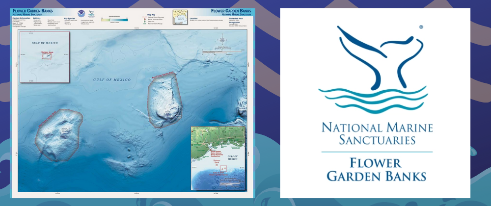
Located in the northwestern Gulf of Mexico, 70 to 115 nautical miles (130 to 213 kilometers) off the coast of Texas (east of Corpus Christi and Houston) and southwest of the Guice Offshore headquarters in Madisonville, Louisiana, the Flower Garden Banks currently encompasses approximately 56 square miles and includes three separate undersea features: East Flower Garden Bank, West Flower Garden Bank, and Stetson Bank.
The banks range in depth from 55 feet (17 meters) to nearly 500 feet (152 meters), and are geological formations created by the movement of ancient salt deposits pushed up through overlying sedimentary layers.
The new expansion, which includes 14 additional reefs and banks in the northwestern Gulf of Mexico, is the outcome of decades of scientific research and growing public recognition of the need for coordinated protection of significant offshore marine places in the northwestern Gulf of Mexico region. Identified during a vigorous public review process of Flower Garden Banks management issues, protecting additional marine habitat in the northwestern Gulf of Mexico emerged as one of the highest priorities.
The region is utilized for a variety of recreational, commercial, and industrial purposes, and there are ongoing impacts from bottom-disturbing activities, such as large vessel anchoring and marine salvage, on the sensitive biological resources and geological features associated with many reefs and banks in the area.
The Flower Garden Banks provide a wide range of habitat conditions that support several distinct marine biological communities, including the northernmost coral reefs in the continental United States and mesophotic coral habitats. These and similar formations throughout the northwestern Gulf of Mexico provide the foundation for essential habitat for numerous marine species, including a variety of fish species of commercial and recreational importance, and several endangered or threatened species, including sea turtles and mobula rays. The combination of location and geology makes the sanctuary an extremely productive and diverse ecosystem.
About the National Marine Sanctuaries Act (NMSA)
The NMSA authorizes the United States Secretary of Commerce (Secretary) to designate and protect as national marine sanctuaries areas of the marine environment that are of special national significance due to their conservation, recreational, ecological, historical, scientific, cultural, archeological, educational, or aesthetic qualities.
Day-to-day management of national marine sanctuaries is delegated by the Secretary to the Office of National Marine Sanctuaries.
The primary objective of the NMSA is to protect nationally significant marine resources, including biological features such as coral reefs, and cultural resources, such as historic shipwrecks and archaeological sites.
The mission of Flower Garden Banks is to identify, protect, conserve, and enhance the natural and cultural resources, values, and qualities of the sanctuary and its regional environment for this and future generations.
This action responds to the need to provide comprehensive and coordinated management of, and additional regulatory protection for, sensitive underwater features and marine habitats associated with continental shelf-edge reefs and banks in the northwestern Gulf of Mexico. The current jurisdictional regime divides authority among several governmental regulatory entities:
Offshore energy exploration: Bureau of Ocean Energy Management (BOEM)
Fishing: Gulf of Mexico Fishery Management Council (GMFMC)
Water quality: Environmental Protection Agency (EPA)
However, it does not provide comprehensive and effective management for the full range of activities that impact the sensitive reefs and banks in the region.
For example, the BOEM has established No Activity Zones (NAZs) that prohibit anchoring only by vessels engaged in development activities and platform services specific to a particular lease, while anchoring by other vessels remains unregulated.
Further, these anchoring regulations in the NAZs apply only on a lease-by-lease basis. Other vessel ground tackle (including anchors, chains, and cables) and marine salvage activities were unregulated and have caused significant injury to sensitive biological communities.
Sanctuary designation will allow for additional protection of these reefs and banks from other bottom-disturbing activities, which are otherwise unregulated at this time.
Most of these areas have also been identified as nationally significant through their designation as Habitat Areas of Particular Concern (HAPC) by the GMFMC and as NAZs by BOEM.
These habitats are vulnerable to a variety of known and potential impacts, including large vessel anchoring, marine salvage operations, fishing techniques that may injure benthic habitat (e.g., trawling, bottom-tending gear), and certain oil and gas exploration and development activities.
Thus, these impacts will more effectively be addressed within the Flower Garden Banks expanded areas through the comprehensive habitat conservation and management authorities under the NMSA. The protection of these ecologically significant sites would increase the resilience of marine ecosystems and enhance the sustainability of the region’s thriving recreation, tourism, and commercial economies. Ultimately, expanding Flower Garden Banks will help ensure that valuable marine resources remain available for the use and enjoyment of future generations of Americans.
What’s In, What’s Out Within the Flower Garden Banks
U.S. Navy Activities—In. In the final rule, NOAA clarifies that the prohibitions in § 922.122(a)(2) through (11) do not apply to the activities being carried out by the Department of Defense as of the date of sanctuary expansion.
Certain types of fishing—Out. Based on the public comments received on the proposed rule, NOAA has decided not to provide exemptions for spearfishing or pelagic longline fishing.
Prohibited: The following activities are subject to regulation, including prohibition, to the extent necessary and reasonable to ensure the protection and management of the conservation, recreational, ecological, historical, research, educational and esthetic resources and qualities of the area:
- Anchoring or otherwise mooring within the Sanctuary;
- Discharging or depositing, from within the boundaries of the Sanctuary, any material or other matter;
- Discharging or depositing, from beyond the boundaries of the Sanctuary, any material or other matter;
- Drilling into, dredging or otherwise altering the seabed of the Sanctuary; or constructing, placing or abandoning any structure, material or other matter on the seabed of the Sanctuary;
- Exploring for, developing or producing oil, gas or minerals within the Sanctuary;
- Taking, removing, catching, collecting, harvesting, feeding, injuring, destroying or causing the loss of, or attempting to take, remove, catch, collect, harvest, feed, injure, destroy or cause the loss of, a Sanctuary resource;
- Possessing within the Sanctuary a Sanctuary resource or any other resource, regardless of where taken, removed, caught, collected or harvested, that, if it had been found within the Sanctuary, would be a Sanctuary resource.
- Possessing or using within the Sanctuary any fishing gear, device, equipment or other apparatus.
- Possessing or using airguns or explosives or releasing electrical charges within the Sanctuary.
- Interfering with, obstructing, delaying or preventing an investigation, search, seizure or disposition of seized property in connection with enforcement of the Act or any regulation or permit issued under the Act.
NOAA is amending the sanctuary boundary descriptions to bring the total Flower Garden Banks area to 160.4 square miles and encompassing 17 banks. The boundary changes were selected through a public process to identify and assess marine areas that could more effectively complement current management authorities or enhance natural and cultural resource values.
Collectively, these new areas capture a greater diversity of habitats and biological resources than currently protected by Flower Garden Banks. Inclusion of these areas within the sanctuary system will provide additional regulatory protection, additional management actions and initiatives, and improved public awareness of their natural resource values.
Flower Garden Banks Expanded Boundaries as of 2021
Detailed maps of these boundary changes are available on the Flower Garden Banks website here.
Under this action, NOAA is expanding the boundaries of the sanctuary by 104.2 square miles from 56.2 square miles to 160.4 square miles as follows:
- Stetson Bank—increase of area by 0.6 square miles from 0.8 square miles to 1.4 square miles
- West Flower Garden Bank—increase of area by 7.22 square miles from 29.94 square miles to 37.16 square miles
- East Flower Garden Bank—increase of area by 2.4 square miles from 25.4 square miles to 27.8 square miles
- Horseshoe Bank—28.7 square miles
- MacNeil Bank—2.7 square miles
- Rankin/28 Fathom Banks—5.6 square miles
- Bright Bank— 7.7 square miles
- Geyer Bank—11.5 square miles
- Elvers Bank—4.6 square miles
- McGrail Bank—4.7 square miles
- Sonnier Bank—3.1 square miles
- Bouma Bank—7.7 square miles
- Rezak Bank—3.7 square miles
- Sidner Bank—2.0 square miles
- Alderdice Bank—5.0 square miles
- Parker Bank—7.0 square miles


