; Deadline Oct. 12, 2023")
Did you know?
In 1807, President Thomas Jefferson signed a mandate ordering a survey of America’s coastlines, which comprise 43,000 square nautical miles of U.S. waters considered critical to navigation.
Today, between 2,000 – 3,000 square nautical miles of U.S. waters are surveyed by the National Oceanic and Atmospheric Administration (NOAA) and commercial contractors annually. These surveys produce 1,000 nautical charts that cover 95,000 miles of shoreline and 3.4 million square nautical miles of U.S. waters.
These specifications are based in part on the International Hydrographic Organization’s Standards for Hydrographic Surveys, Special Publication 44 and define standards and requirements on the following topics:
- Horizontal and vertical position uncertainty
- Tides and water levels requirements
- Coverage and resolution requirements for multibeam, singlebeam, side scan, and lidar data
- Features
- Required field reporting
Now, NOAA has recently revised the Hydrographic Survey Specifications and Deliverables (HSSD) to better accommodate new and developing hydrography technologies and increasing amounts of externally-sourced hydrographic data submissions. While this renewed version of the document was developed by NOAA hydrographers, it benefits greatly from external review from the larger hydrographic community, thus NOAA seeks public comment from a wide range of stakeholders and subject matter experts to provide input and inform its finalization.
A draft of the new Hydrographic Survey Specifications and Deliverables document from NOAA’s Office of Coast Survey is currently posted to the Federal Register, where it will be available for public comment until October 12, 2023.
To read the draft HSSD, click here.
All interested parties are encouraged to review the draft and provide feedback via the instructions provided in the Federal Register Notice here.
The project to renew the Hydrographic Survey Specifications and Deliverables document commenced with a particular vision—to rewrite specifications as forward-looking with respect to new and developing technology, to best facilitate automation, and to better integrate with S-100 based standards and the National Bathymetric Source, a project that creates and maintains high-resolution bathymetry composed of the best available data.
The final HSSD document will better accommodate increasing amounts of hydrography data received from external sources, with metadata tags to denote data quality and universal data licenses to define terms of use, resulting in a more streamlined, standardized process. It will modernize workflows and play a key role in the future of NOAA’s Office of Coast Survey as a data-driven organization.
NOAA promulgates standards and specifications for hydrographic data in the HSSD in order to ensure safe and efficient navigation in support of our maritime economy in accordance with the Coast and Geodetic Survey Act, 33 U.S.C. 883 et seq., and the Hydrographic Services Improvement Act, 33 U.S.C. 892 et seq.,
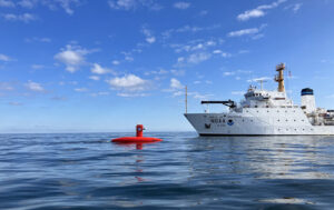
Currently, beta-testing of the draft specifications in the field is happening aboard NOAA Ship Thomas Jefferson, and Navigation Response Team Seattle is planning similar testing in September. The field tests will help quantify the operational impacts and readiness of the new specifications.
The Hydrographic Survey Specifications and Deliverables document is the product of many subject matter experts who graciously volunteered their time and effort. From NOAA hydrographers who have already provided input, to all of those external to NOAA whose input is yet forthcoming—their contributions are appreciated.
Guice Offshore Vessels Work With Scientific and Government Researchers; Even Documentary Filmmakers
Guice Offshore (“GO”)’s fleet is regularly employed in a variety of support roles for hydrography, bathymetry, ocean science research and development, and other special projects requiring top-of-the-line, highly dependable offshore support vessels. Our multi-purpose vessel GO America, based in Port Everglades, Florida, operates in conjunction with our partners Global SubDive to support a large array of science and research projects, often utilizing GSD submarines and ROVs. Similarly, partner Ryan Marine is an expert in the field of unmanned vehicle operation, which allows us to provide turnkey AUV and UUV services anywhere in the United States and Caribbean.
Guice Offshore vessels like the 150 ft. DP1 GO Liberty or the 170 ft. DP1 GO Discovery are often used by geotechnical and other types of companies to perform detailed survey activities such as seabed mapping, soil investigations and core sampling. Depending on their equipment installed, our vessels can work in a variety of coastal or offshore environments and water depths. The open cargo deck, ample accommodations, excellent maneuverability and station-keeping, all coupled with an efficient cost of operations, makes the Guice Offshore fleet a consistently reliable choice for those needing an offshore supply vessel or marine transport.
For researchers looking to document their missions, Guice Offshore vessels also support movie and television productions, whose crew needs capable vessels like ours to film scenes, house crews or transport between sets. Our vessels have participated in the filming of feature films movies Deepwater Horizon and Isolation. GO America was also supporting actor in the TV series Cooper’s Treasure Season 2 and Shark Week’s “Tiger Shark King” episode. GO vessels have even been mentioned on national news programs for their participation in life-saving rescues or other offshore recovery missions. With our partners, submarines and ROVs can be provided to assist with underwater cinematography.
