
MarineCadastre.gov is marking its 15th year as an authoritative source for marine and coastal maps and information to support a wide array of ocean users and regulators by adding new and updated data and services.
Marine Cadastre was developed in 2009 in response to the Energy Policy Act of 2005, which called for such an authoritative mapping data source. The tool was then developed in a cooperative effort between BOEM and NOAA as an online, interactive map viewer that integrates coastal, oceans, and great lakes information in a common reference framework. The information consists of legal, property ownership (cadastre), physical, biological, ocean uses, and cultural information from multiple agencies.
Users include Guice Offshore clients like coastal and offshore resource management agencies, state governments, and regional and state portals that pull from MarineCadastre.gov, educators, offshore industry, NGOs, and any other stakeholder that is interested or concerned about activities and plans on our nation’s Outer Continental Shelf.
Utilizing vessels like the Guice Offshore 150 ft DP1 GO Liberty and data from Marine Cadastre, companies like geotechnical surveyors can perform detailed survey activities for their clients, such as seabed mapping, soil investigations and core sampling. Depending on their equipment installed, Guice Offshore vessels can work in a variety of coastal or offshore environments and water depths. The open cargo deck, ample accommodations, excellent maneuverability and station-keeping, all coupled with an efficient cost of operations, makes our GO fleet a consistently reliable choice for this industry.
Data are also used by citizens for commenting to governments, by planners for environmental analysis, intergovernmental planning, maps and visuals at various meetings, press briefings, and general information and outreach. The project is often used within academic curriculums to teach students about GIS and Marine Spatial Planning in U.S. waters.
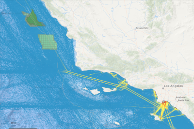
A growth area for the tool has been including vessel transit counts using data from the Automatic Identification Systems (AISs) that mariners provide to the U.S. Coast Guard. To serve growing interest in this data, the MarineCadastre team will offer a new portal in 2022 called AccessAIS. This tool will enable users to interactively download U.S. vessel traffic data across user-defined geographies and time periods. It also provides quick visualization of vessel traffic densities and patterns using underlying map services derived from the same point data that are available for download via the application.
During 2021, the MarineCadastre team updated 24 web services showing such things as Blue Whale Pacific densities in summer and fall, ocean dump sites, offshore oil and gas platforms and wells, and many more. The team also developed 28 data sets for MarineCadastre applications.
How Can You Partner With Marine Cadastre?
The MarineCadastre.gov is the result of a collaborative effort among a number of organizations. This team of participants is engaged in and provides data through the Digital Coast and the Data.Gov Ocean Community.
MarineCadastre.gov is recognized by regional ocean governance groups as the central place for authoritative federal data, with data, metadata, and map services from the project being integrated into the Northeast Ocean Data Portal, Mid-Atlantic Ocean Data Portal, and West Coast Ocean Data Portal.
The team is coordinating with the ocean planning groups on data and sharing lessons. The Frequent Questions page details other collaborative efforts and further defines mechanisms for collaboration. This initiative continues to grow and strengthen as a result of such partnerships. If you are interested in partnering or contributing data, please email info@marinecadastre.gov.
About MarineCadastre.gov
MarineCadastre.gov was developed through a partnership between the U.S. Department of Commerce’s National Oceanic and Atmospheric Administration (NOAA) Office for Coastal Management and the U.S. Department of the Interior’s Bureau of Ocean Energy Management (BOEM).
MarineCadastre.gov is an integrated marine information system that provides data, tools, and technical support for ocean and Great Lakes planning. MarineCadastre.gov was designed specifically to support renewable energy siting on the U.S. Outer Continental Shelf but also is being used for other ocean-related efforts.
The MarineCadastre.gov team is continually working to increase access to data through data and map services. The services are designed to deliver data without replication and directly from the source. MarineCadastre.gov supports a number of complementary efforts, including Digital Coast, Data.gov and Geoplatform.gov. People are encouraged to use these data map services in their mapping initiatives. Those who have data useful for marine planning, please email info@marinecadastre.gov.
MarineCadastre.gov was created to comply with Section 388 of the Energy Policy Act of 2005 but is also providing the geospatial framework needed for the broader marine spatial planning initiative called for in the National Ocean Policy.
— BOEM —
The Department of the Interior’s Bureau of Ocean Energy Management (BOEM) is responsible for America’s offshore energy and mineral resources. The bureau promotes energy independence, environmental protection and economic development through responsible, science-based management of energy and mineral resources on the U.S. Outer Continental Shelf.


