
From the end of the last Ice Age, when sea levels were about 200 feet lower than they are today, to more recent times during the past 400 years, the underwater floor of America’s Outer Continental Shelf tells many tales of our history that might not have otherwise been discovered without the impetus of oil and gas exploration and its connection to marine archaeology.
In fact, many fascinating archaeological sites in the Gulf of America have been discovered by geophysical surveys of the ocean floor that were conducted by oil and gas industry operators in order to meet the requirements of federal laws and Bureau of Ocean Energy Management (BOEM) regulations. Bottom-disturbing operations such as well placement, anchoring, and pipelaying activities can lead to damage to any resources that reside on the seabed, particularly historic shipwrecks.
Whether it’s scientific research or offshore energy operations, Guice Offshore assists with both specialty industries by providing dynamically positioned offshore vessels equipped with state-of-the-art maritime technology, plenty of crew quarters, ample deck space and heavy equipment to carry remote operated vehicles equipped with sensitive tools used to detect where archeological sites may exist.
Visit the BOEM Archaeological Museum HERE.
According to BOEM, most archaeological sites on the Outer Continental Shelf are most likely to be either pre-contact Native American sites or historic shipwrecks dating from as early as the 16th century A.D. and as recent as World War II. Specialized instruments used to detect these sites include a magnetometer, which detects ferrous metals, a sidescan sonar, which creates a picture of the seafloor using reflected sound waves, and a sub-bottom profiler, which detects variations in the sediment underlying the seafloor, the BOEM explains. The data collected by these instruments are then reviewed by archaeologists, who write reports on their findings for submittal to BOEM or Bureau of Safety and Environmental Enforcement (BSEE), as appropriate.
To view and query high resolution geophysical surveys that have been completed in the Gulf of America and submitted to BOEM as geohazard/archaeology reports, click HERE.
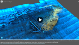
Historical research indicates that over 2,000 ships have sunk on the federal Outer Continental Shelf between 1625 to 1951, while thousands more have sunk closer to shore in state waters during the same period. Only a handful of these have been scientifically excavated by archaeologists to date. The work conducted by BOEM and other researchers and scientists in the Gulf of America contributes not only to energy development, but to the understanding of how ancient technology fostered the growth of the United States through the commerce and culture of bygone eras.
Below is a series of websites devoted to some of these discoveries, or click HERE to access the BOEM library of historic shipwreck documentation that includes:
- Ships of Exploration
- 19th Century Steamships
- Civil War Shipwrecks
- World War II Shipwrecks
- Deepwater Shipwrecks
- Archaeology Index Page
Other Popular BOEM Discoveries
- The Mardi Gras Shipwreck
- The Story of U-166
- Lophelia II: Rigs, Reefs, and Wrecks
- Historic Shipwrecks in the Gulf of America
- Gulf of America Expedition Discovers Amazing Historic Shipwreck
- The Gulf of America Shipwreck Corrosion, Hydrocarbon Exposure, Microbiology, and Archaeology project (GOM-SCHEMA)
- Virtual Archaeology Museum
- Historic Sailing Routes in the Gulf of America Application (This site allows the user to view the geo-rectified courses of ships taken over the past 400 years).
 Strengthens Offshore Wind Safety with New Standard; Platform Supply Vessel")

")