
Two next-generation satellite missions announced during early February 2025 are expected to help NASA better understand Earth and improve capabilities to foresee environmental events and mitigate disasters.
Described below, these two missions were selected for continued development as part of NASA’s Earth System Explorers Program, which conducts principal investigator-led Earth science missions based on key priorities laid out by the science community and national needs. The program is designed to enable high-quality Earth system science investigations to focus on previously identified key targeted observables.
“NASA uses the unique vantage point of space to study our home planet to deliver life-saving data into the hands of disaster response and decision-makers every day for the benefit of all, while also informing future exploration across our solar system,” said Nicky Fox, associate administrator, Science Mission Directorate, NASA Headquarters in Washington. “By understanding Earth’s surface topography, ecosystems and atmosphere, while also enabling longer range weather forecasting, these missions will help us better study the extreme environments beyond our home planet to ensure the safety of astronauts and spacecraft as we return to the Moon with the Artemis campaign and journey onward to Mars and beyond.”
The selected missions will advance to the next phase of development. Each mission will be subject to confirmation review in 2027, which will assess the progress of the missions and the availability of funds. If confirmed, the total estimated cost of each mission, not including launch, will not exceed $355 million with a mission launch date of no earlier than 2030.
For more information about the Earth System Explorers Program, visit:
https://explorers.larc.nasa.gov/2023ESE
The STRIVE (Stratosphere Troposphere Response using Infrared Vertically-resolved light Explorer) mission will provide daily, near-global, high-resolution measurements of temperature, a variety of Earth’s atmospheric elements, and aerosol properties from the upper troposphere to the mesosphere – at a much higher spatial density than any previous mission. It also will measure vertical profiles of ozone and trace gasses needed to understand the recovery of the ozone layer. The data collected from STRIVE would support longer-range weather forecasts, an important tool in protecting coastal communities, where nearly half the world’s population lives. The mission is led by Lyatt Jaeglé at the University of Washington in Seattle.
NSF NCAR researchers Helen Worden, former deputy director of Atmospheric Chemistry Observations and Modeling and John Gille, senior scientist emeritus are both co-investigators on the project.
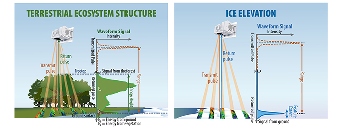
The EDGE (Earth Dynamics Geodetic Explorer) mission will observe the three-dimensional structure of terrestrial ecosystems and the surface topography of glaciers, ice sheets, and sea ice. The mission will provide an advancement beyond the measurements currently recorded from space by NASA’s ICESat-2 (Ice, Cloud, and land Elevation Satellite 2) and GEDI (Global Ecosystem Dynamics Investigation). The data collected by EDGE will measure conditions affecting land and sea transportation corridors, terrain, and other areas of commercial interest.
Scripps Oceanography Scientist to Lead Launch of First Global Satellite Imaging Laser Altimeter System
The mission is led by Scripps Institution of Oceanography glaciologist Helen Amanda Fricker at the University of California San Diego.
EDGE will provide an advancement of observations of land, vegetation, ice and coastal regions, and is the first NASA satellite mission to be led by UC San Diego.
With Fricker serving as principal investigator (PI), EDGE will be the first global satellite imaging laser altimeter system. Laser altimetry is a technology that sends laser pulses to Earth’s surface and records the time it takes them to return to the spacecraft. Scientists measure how long they laser light takes to to bounce back to measure the height and structure of Earth’s surface. This technology allows scientists to make high-resolution, three-dimensional observations of the structure of terrestrial ecosystems like forests and the surface features of glaciers, ice sheets and sea ice.
“NASA’s selection of the UC San Diego Scripps Institution of Oceanography-led EDGE mission is a landmark affirmation of our university’s world-renowned leadership in space-related research,” said UC San Diego Chancellor Pradeep K. Khosla. “UC San Diego continues to push the frontiers of planetary research, informing critical policy decisions and delivering innovative solutions. With this dedicated satellite system, we are expanding our observational purview to global, continuous coverage. This achievement reaffirms the power of our long-standing commitment to understanding and protecting the planet — an effort that drives scientific discovery and strengthens national security and economic prosperity for the benefit of all.”
Fricker has worked on NASA satellite missions since 1999. She was a member of NASA’s Ice, Cloud, and land Elevation Satellite (ICESat) Science Team and is the current science team lead for ICESat-2, launched in 2018. Also in 2018, the Global Ecosystem Dynamics Investigation (GEDI) instrument was deployed onto the International Space Station (ISS), and together these satellites have been vital in monitoring the whole Earth.
“Congratulations to Prof. Fricker and the EDGE team on this transformative achievement,” said Meenakshi Wadhwa, director of Scripps Oceanography and vice chancellor for marine sciences at UC San Diego. “As UC San Diego’s first PI-lead NASA mission, this is a great example of the ingenuity and leadership of Scripps scientists, whose work helps keep the United States at the forefront of global technological innovation to observe our planet, and deliver in-demand and critically important data to decisionmakers.”
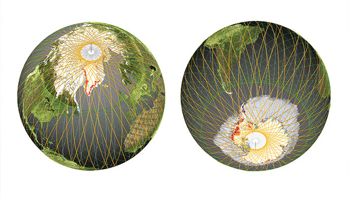
The EDGE mission builds on heritage from GEDI and ICESat-2, led by NASA Goddard Space Flight Center. NASA Goddard will also be the implementing center for EDGE. EDGE will be the first swath-mapping lidar in space with new technology that will have an increased density of laser beams that will map the planet using five 120-meter (400-feet) wide strips. This provides much higher resolution and accuracy, enabling a more comprehensive view of the dynamics of the Earth’s surface. This resolution of the depth, height and structure of terrestrial, polar and coastal systems will bring Earth’s features into focus to enable understanding of the processes driving change.
Capturing accurate data in these critical regions is crucial for greater understanding of the state of Earth’s systems, as well as supporting national security, global transportation, water resource planning, risk management and providing strategic environmental intelligence to policymakers.
“I am so delighted to lead the EDGE mission, bringing together a cross-disciplinary team of scientists and engineers with a shared goal of developing a next-generation instrument to measure the vital signs of our planet in our most critical regions,” said Fricker, who also serves as the director of the Scripps Polar Center. “EDGE mini-swaths will provide unmatched global coverage, exceeding all prior laser altimeter missions to bring key features into clear focus, and extend lidar records for decadal change detection.”
EDGE aims to expand global coverage of vegetation and provide dense mapping around the edges of ice sheets and sea ice packs, in the Earth’s polar regions. To achieve this global coverage, along with the required pointing stability and agility, EDGE will fly on a Lanteris 500™ series spacecraft from Lanteris Space Systems, a wholly owned subsidiary of Intuitive Machines.
The EDGE team comprises of 25 scientists and engineers from around the world. In addition to Fricker, leadership includes deputy PI John Armston from the University of Maryland, and Instrument PI Bryan Blair and Project Scientist Scott Luthcke from NASA Goddard Space Flight Center. Scientists from the University of Maryland, U.S. Forest Service, George Mason University, Boise State University, U.S. Geological Survey, Bristol University, UCLA, National University of Singapore, German Aerospace Center, and the Smithsonian Tropical Research Institution round out the team for terrestrial ecosystem structure, while the ice elevation team features scientists from the University of Michigan, University of Washington, University at Buffalo, Colorado School of Mines, Woods Hole Oceanographic Institution, the Australian Antarctic Division and Fricker’s alma mater, the University of Tasmania.
###
Guice Offshore, one of the nation’s most respected providers of mini supply vessels for specialty markets, is experienced in handling offshore operations for the space and aerospace industries.

")
