Guice Offshore co-founders Nathan and Billy Guice are among the mentors participating in the inaugural cohort for the new Gulf Blue “Navigators” business incubator designed to assist bluetech startups that already have a pilot program in place and are ready to scale.
Bluetech industries include precision marine aquaculture, sea and space systems, ocean data and analytics, uncrewed systems, ocean-friendly plastics, smart ports and smart shipping.
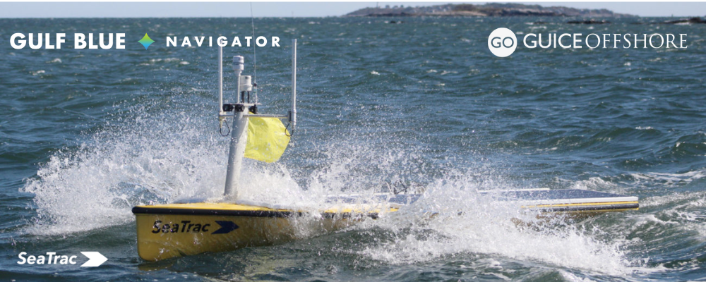
“Especially given Guice Offshore’s work with military, defense, energy and environmental industries, we’re pleased to have been assigned to mentor Seatrac, which designs and develops uncrewed surface vehicles for persistent in-shore and open-ocean missions,” Billy explained. “We’ll also be hosting a round table where those of us who have taken a similar path in business can share their experiences with startups like Seatrac.”
Propelled by energy derived from onboard solar panels, Seatrac vehicles are powered by a highly efficient electric motor fueled by substantial battery storage that allows for consistent cruise speeds over days with varying weather conditions. Seatrac helps to collect information about the ocean better, faster and more economically than traditional methods by using a broad array of compatible sensors and intuitive software controls provide to provide users with access to a wide range of environments and marine data.
Gulf Blue’s Navigator program was created to assist established startups in need of technical testing facilities and infrastructure, as well as provide access to partners and potential customers. Throughout the program, Gulf Blue Navigator provides the tools, resources and network needed to reach the startup’s next stage of development, while also helping them navigate a path forward with the federal agencies, industry and investors required bring a project to scale.
Including Seatrac, six companies were selected in November 2022 as the first cohort of Navigator participants. To kick off the program, the group visited three Gulf Blue coastal counties as a first step to developing partnerships to accelerate commercialization.
All will give their final presentations in May 2023.
The University of Southern Mississippi Research Foundation and SeaAhead, with the support of partners including Jackson State University, selected Seatrac and the other startups in the new program from a pool of 48 applicants across 12 countries.
With an emphasis on shortening the timeline of development and market access, the Gulf Blue Navigator positions blue technology startups for success by leveraging the existing strengths and capabilities of the Mississippi Gulf Coast.
Along with the others participating in the program, Seatrac will be provided with access to advanced interactive workshops taught by practitioners in the bluetech field, site visits with large industry and federal agencies, co-working space at the historic Gulf and Ship Island Building in Gulfport, and customized mentorship to meet the needs of each startup.
“This group of startups is leading the way towards positive impact with new solutions and new ways of thinking,” Gulf Blue explained. “They apply visionary thinking to the Gulf of Mexico to navigate a new world where we can positively impact ocean and environmental health while creating equitable jobs for a fast growing-global economy. The first cohort’s success will demonstrate the possibilities the Gulf of Mexico and Coastal Mississippi has to offer, establishing Mississippi’s place as a blue economy innovation district.”
Altogether, the selected startup companies are:
SeaTrac Systems: Persistent, multi-purpose solar-powered Uncrewed Surface Vehicles (USVs) to efficiently, safely and cost effectively perform real-time data collection and communications for research, commercial and defense applications. (HQ: Massachusetts)
Blue Ocean Gear: Intelligent tracking buoys for commercial fishing fleets, aquaculture farms, and ocean observers, helping them save time and money while gaining critical operational insights. (HQ: California)
Marauder Robotics: Remote work platform that collects critical ecosystem data in near real-time and automates underwater tasks done by divers to restore biodiversity. (HQ: Georgia)
BeeX: Advanced underwater vehicles with the ability to swarm targets working in tandem with software tools to help reduce the costs and risks of underwater work at scale. (HQ: Singapore)
Safety Net Technologies: Solutions that enable sustainable practices in the fishing industry for a world where oceans and people thrive together. (HQ: United Kingdom)
SEATREC: (Note: this is different than Seatrac) Energy harvesting systems that generate electricity from naturally occurring temperature differences in ocean waters to power deep water oceanographic research equipment such as floats, gliders, and Autonomous Underwater Vehicles (AUVs), for cost-effective deep ocean data collection. (HQ: California)
What Can SeaTrac Do?
As a complete system for autonomous observation, data collection, and reconnaissance, SeaTrac normally makes decisions on its own, but can also support “person in-the-loop” and remote control. Missions can be easily changed on the fly, making these unmanned vehicles extremely useful and cost-effective in an array of industrial applications.
Offshore energy operators like offshore wind, or oil and gas, can use SeaTrac to:
- Gain real-time data on wind, air temperature, water temperature, wave height, surface and subsurface current at any remote location.
- Monitor the ocean surface over a wide area and around the clock to assist in hydrocarbon monitoring during oil spill response efforts.
- Improve the accuracy and effectiveness of collected data through unmanned underwater vehicle tracking by providing position fixes for these and other subsea vehicles such as underwater gliders.
- Harvest data and function as a communications relay by providing real-time, continuous access to undersea sensors or vehicles without the need for sending out a ship.
- Conduct cost-effective unmanned hydrographic surveys with side scan and multibeam sonar near shore or out in exposed waters.
- Perform passive acoustic monitoring by obtaining long endurance, around-the-clock monitoring for whales or other mammals around offshore projects with hydrophones or hydrophone arrays.
The defense industry can use SeaTrac to:
- Obtain more real-time intelligence with less risk and lower cost. The Department of Defense envisions unmanned systems seamlessly operating with manned systems to improve warfighters’ decision-making process.
- Assist in intelligence, surveillance and reconnaissance (ISR) below the ocean surface by listening (hydrophone) and actively seeking (sonar) underwater targets. Above the surface, it can monitor (audio / video) and seek (radar) surface or airborne targets. Together these systems create a cost-effective, over-the-horizon wide area electronic fence.
- Function as a communications relay by passing data across subsea, aerial, and land-based assets to improve decision making. Harvesting data from undersea assets without sending out a ship. Gain real-time, continuous access to undersea data from deployed assets.
- Obtain real-time local data (wind, waves, surface and subsurface currents, and ocean temperature) to improve situational awareness.
- Provide position fixes for subsea assets like unmanned underwater vehicles to improve the accuracy and effectiveness of collected data.
- Conduct unmanned hydrographic surveys with side scan and multibeam sonar in areas prohibitive to manned vessels or UUVs.
- Distract an antagonist with a cost-effective decoy.
The environmental industry can use SeaTrac to:
- Obtain more real-time information at a lower cost and with more flexibility. Research vessels and buoys are costly to deploy and manage: unmanned vehicles can provide an effective alternative in many applications.
- Gain cost-effective, real-time data on wind, air temperature, water temperature, wave height, surface / subsurface current at any remote location to improve weather and ocean models.
- Sample the surface water over large areas to monitor the impact of drainages, water treatment outflows, eelgrass health, harmful algae blooms, and other human activity affecting water quality.
- Conduct cost-effective unmanned hydrographic surveys with side scan and multibeam sonar near shore or out in exposed waters.
- Harvest data from undersea modems without sending out a ship. Gain real-time, continuous access to undersea data from fish tags.
- Obtain long-endurance, around-the-clock monitoring for whales or other mammals with hydrophones or hydrophone arrays.
About the Gulf Blue Navigator Program
The Gulf Blue Navigator Program was established by the University of Southern Mississippi Research Foundation and SeaAhead, which specializes in high-potential, ocean-focused technology startups, building global networks, and venture financing.
Mark Huang, Managing Director of SeaAhead, said, “The Gulf Blue Navigator program will act as a ‘Gateway to the Gulf,’ inasmuch as it is a bridge to connect promising bluetech startups to the unique capabilities and infrastructure on the Mississippi Gulf Coast.”
The Gulf Blue Navigator is made possible by the participation, support and financial contributions of Gulf Blue sponsors and partners who assist with recruitment, selection, curriculum, mentoring and more. This program is funded by the Builders Initiative, Mississippi Department of Environmental, Members of Coast Electric Power Association through their Operation Round Up program in partnership with the Gulf Coast Community Foundation, with additional financial support from Harrison County Development Commission, Port of Gulfport, Huntington Ingalls Industries, Leidos, Hancock County Port & Harbor Commission, and Keesler Federal Credit Union.
Peter Bryant, Program Director for Builders Initiative, said, “Gulf Blue Navigator is a great program that will help advance blue economy business solutions to solve some of the most pressing issues facing our oceans. The combination of the academic leadership of The University of Southern Mississippi, the waterfront Gulfport location, and the business accelerator support of SeaAhead’s venture studio programs will spur innovation and help burgeoning entrepreneurs in the blue economy obtain the skills and assistance they need to grow their businesses.”
The Gulf Blue initiative pools the knowledge of research scientists, federal agencies, industry partners, and entrepreneurs to further develop our region into a global leader in blue technology. Our history, geography, and maritime resources position the Gulf Coast to lead the development of world-changing innovation that will emerge out of the blue in Mississippi.


