")
During early March 2026, the National Oceanic and Aeronautics Administration (NOAA) and Northrop Gruman, a major American global aerospace and defense technology company, released the first-ever high definition sonar images of the USS Monitor shipwreck site during a media briefing that included other research presentations.
The USS Monitor was the United States Navy’s first commissioned ironclad warship, famously designed by John Ericsson and launched in 1862 during the American Civil War and best known for its low-profile designed for coastal operations and its revolutionary 20-foot diameter, steam-powered, revolving turret containing two 11-inch Dahlgren smoothbore guns. But due to its poor sea-keeping ability, the ship sank during a storm off Cape Hatteras, North Carolina on December 31, 1862.
On January 30, 1975, NOAA designated the wreck of the USS Monitor as the nation’s first national marine sanctuary. Over 45 years later, Monitor National Marine Sanctuary continues to protect this famed Civil War ironclad. NOAA’s Office of National Marine Sanctuaries manages the shipwreck through long-term monitoring, research, and public engagement. Once a marvel of 19th-century naval engineering and a weapon of war, the Monitor continues to serve America today through technology, innovation and education.
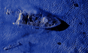
In September 2025, members of Northrop Grumman’s Technology for Conservation team, along with scientists from NOAA and Stantec deployed an AUV (Autonomous Underwater Vehicle) with an advanced sonar system, µSAS, to capture high-resolution imagery of the Monitor shipwreck site off Cape Hatteras, North Carolina.
µSAS™ (pronounced micro-SAS) is a first-of-its-kind synthetic aperture sonar (SAS), which allows underwater vehicles to capture precise and high-resolution imagery of the ocean and seabed. By collecting and processing sonar data in real-time, µSAS gives missions the information they need for situational awareness and informed decision-making.
The advanced system penetrates low-visibility conditions to generate extraordinary, high-resolution imagery of the wreck and its surrounding debris field, including detailed views of hull remains and internal structure.
These fine-scale sonar scans will be used to help researchers, historians and the public explore, understand and protect NOAA’s Monitor National Marine Sanctuary and America’s most famous Civil War shipwrecks.
Scientists from SEARCH participated in some of the planning meetings.
Those on hand for the announcement also had the opportunity to tour the Batten Conservation Complex, the primary conservation facility for artifacts recovered from the Monitor, including the revolving gun turret, Dahlgren guns, and steam engine.
Today, the USS Monitor rests nearly 240 feet below the ocean’s surface at the Monitor National Marine Sanctuary, where it now functions as both a cultural resource and a thriving artificial reef. The sanctuary team regularly monitors the site to better understand how the wreck is changing over time and how marine life is using the structure. High-resolution mapping plays a key role in that stewardship, allowing scientists to document conditions without disturbing the fragile site.
The Mariners’ Museum and Park in Newport News, Virginia, which hosts the annual Battle of Hampton Roads Commemoration Day, is the principal repository and conservation facility for USS Monitor artifacts recovered from the site, and the official visitor center for Monitor National Marine Sanctuary.
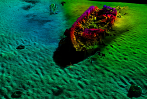
In partnership with NOAA’s Monitor National Marine Sanctuary and Northrop Grumman, The Mariners’ Museum and Park in Newport News, Virginia revealed stunning new three-dimensional digital reconstructions of Monitor as it appeared in 1862, alongside the remarkably detailed scans of the wreck as it rests today on the ocean floor.
As the Monitor Marine Sanctuary marks its 50th anniversary, the collaboration honors Monitor’s legacy by returning to the site with 21st-century tools, expanding opportunities for conservation, education, and engagement in ways never before possible.
“By unveiling this new technology alongside hands-on STEM activities, we’re showing the community that history and innovation go hand in hand,” said Will Hoffman, Director of Conservation and Chief Conservator. “These experiences provide visitors a new window into the past, enabling people to engage with USS Monitor through a different lens, and potentially, drawing in new audiences of all ages to learn about the little ship that saved the nation!”
In addition to providing NOAA with valuable new data, the project offered the engineering team experience operating the technology in a novel field setting. The work aligns with Northrop Grumman’s Technology for Conservation (T4C) initiative, which applies engineering expertise to conservation efforts.
Kevin Gallagher, a key engineer architect on the µSAS team, explains that while this technology has been used by Northrop Grumman on projects before, it has never been used in a way where the data was made publicly available. “For our µSAS team, this was an opportunity to show how we’re using this high-res imagery and 3D tech beyond the aerospace and defense industry, growing our reach and capability of µSAS,” Gallagher commented. “We were able to capture detailed images of the shipwreck and surrounding debris field, assisting NOAA in collecting biological data to further identify what species inhabit the area.”
Also present at the March announcement were:
- Sabrina Jones, senior director of advancement, The Mariners’ Museum and Park
- Jeff Gray, NOAA’s Office of National Marine Sanctuaries acting director, Northeast and Great Lakes Region
- Tane Casserley, research and resource protection coordinator, NOAA’s Monitor National Marine Sanctuary
- Mike Witt, Ph.D, vice president and chief environment, quality and safety officer, Northrop Grumman
- Kevin Gallagher, sonar architect, Northrop Grumman
- Jennifer VanBerschot, technical lead, Northrop Grumman
- Kelly Swindle, senior marine biologist, Stantec


